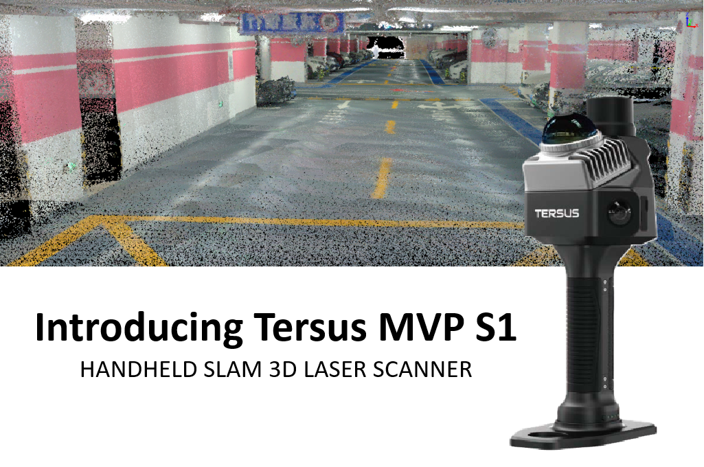
High‑precision mobile SLAM laser scanning that isn’t complicated or expensive.
The Tersus MVP S1 is built for teams that need reliable, everyday 3D capture without the cost or complexity of traditional scanning systems. With advanced AI‑driven RTK‑SLAM, photorealistic point clouds, and true walk‑and‑scan simplicity, the S1 finally brings high‑end performance to a wider range of organizations.
And at Geo Week 2026, we’re giving one away. Visit Booth 1223 to enter the MVP S1 giveaway and see live demos.
From complex interiors to roadways, forestry, tunnels, stockpiles, and digital twin workflows, the S1 is built for real‑world conditions and real‑world speed.
Built for Everyday 3D Capture
At the heart of the Tersus MVP S1 is a refined, stability‑focused AI‑driven RTK‑SLAM algorithm that fuses LiDAR, vision, and GNSS to produce clean, photorealistic, well‑aligned point clouds.
Even in visually challenging or geometrically complex environments, the Tersus MVP S1 maintains residual control and delivers clean geometry. The result:
- Fewer return visits
- Less rework
- Faster field‑to‑deliverable workflows
- High‑quality data in the palm of your hand
Export directly into your existing workflow with support for JPG, LAS, RCP, and PLY.
Where the Tersus MVP S1 Excels
Complex Sites & Confined Spaces
Walk‑and‑scan capture for stairs, corridors, multi‑level interiors, and irregular spaces. Real‑time feedback helps teams identify gaps or shadowed areas before leaving the site.
Roadways, Safety & Infrastructure
Rapid documentation of intersections, corridors, ADA compliance areas, and active traffic zones, minimizing time in harm’s way and reducing reliance on tripod‑based terrestrial scanning. Ideal for tunnels, utility corridors, and underground environments.
Forestry & Canopy Environments
Efficient collection in dense stands for tree inventory, DBH analysis, forest structure assessment, carbon verification, and digital forest twin workflows. Dual cameras produce true‑color point clouds for faster species identification and environmental analysis.
Indoor Mapping & Digital Twins
Fast indoor capture for BIM, GIS, and CAD. Perfect for utilities, mechanical rooms, and facility management across complex infrastructure.
Visualization & Project Insight
High‑resolution visual data supports photorealistic deliverables and advanced visualization workflows, including Gaussian Splatting to improve communication, track progress, and reduce return visits.
Volumetric & Earthwork
Instant, accurate stockpile and excavation measurements. Replace manual methods with rapid mobile scanning for precise volume calculations and inventory management.
See It. Test It. Win It.
If you’re heading to Geo Week, stop by Booth 1223 for live demos, hands‑on testing, and a chance to win a Tersus MVP S1. It’s the perfect opportunity to experience the S1’s speed, simplicity, and data quality firsthand.
Advanced mobile SLAM is now practical, portable, and priced for everyday field use.
Contact us today for your price quote.